 |
Circle Genealogic and Historic Champanellois Association "Law 1901" of Saint-Genès-Champanelle, 63 , France |
|
|
Circle Genealogic and Historic Champanellois Association "Law 1901" of Saint-Genès-Champanelle, 63 , France |
|
![]()
Geographical presentation
![]()

| country | France |
| area | Auvergne |
| department | Puy-de-Dôme - (63) |
| canton | Beaumont |
| commune | Saint-Genès-Champanelle |
| district for the election ofthe deputy |
3ème - Clermont montagne |
![]()
Fast
map of the commune drawn by Thomas |
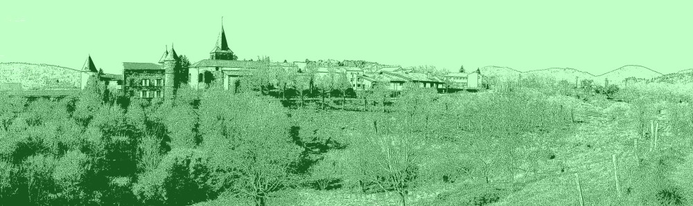
| The
commune is located close of the town of Clermont-Ferrand (from 12 to 18 km according to villages) to the heart of France. |
| It
consists of 12 villages whose
majority are at the east of the territory of the
commune, the west being occuped by the volcanos of the chain of the Dômes. |
| 1. | Beaune | 5. | Fontfreyde | 9. | Pardon |
| 2. | Berzet | 6. | Laschamps | 10. | Saint-Genès-Champanelle |
| 3. | Champeaux | 7. | Manson | 11. | Thèdes |
| 4. | Chatrat | 8. | Nadaillat | 12. | Theix |
| Its coordinates geographical are as following : |
| longitude | latitude |
| 0,758 grades | 50,8 grades |
| 03°01'11" | 45°43'16" |
The highest point is to 1255 m, it is the PUY DE LASCHAMPS. To annouce : the PUY DE LA VACHE and the PUY DE LASSOLAS, in the horseshoe shape becouse the crater exploded side. With its 55,58 km2, it is the sixth commune of the department of Puy de Dôme, surface. The
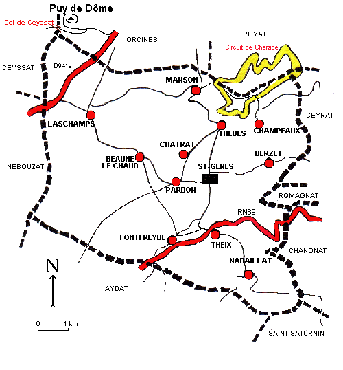
communes bording are 9 : The territory of the commune is crossed by 2 trunk roads : RN89 and RD941a which go in direction of south-west towards Bordeaux. The road racing set of Charade also called "Circuit of Auvergne", is divided between the commune of Royat and of Saint-Genès-Champanelle. The new made safe ring, shorter, is only on the commune of Saint-Genès-Champanelle. |
![]()
Regional natural reserve of the Volcanos of Auvergne
Saint-Genès-Champanelle is located on the territory
of the Regional natural reserve of the Volcanos of Auvergne, created on March 1,
1967.
| Its adress : | Maison du parc Montlosier 63970 Aydat Telephone : 04 73 65 64 00 |
 |
It is the vastest park of France with 393 000
hectares
and it gathers 153 communes lodging 92 000 inhabitants
(data 2000).
* [ back to the presentation ] * [ back to the welcome page ] * [ back to the good answers ] *
![]()
| listed crosses | 59 |
| old postcards of the commune | 156 |
| old postcards except commune | 47 |
| old postcards of the volcano Puy de Dôme | 118 |
| associations listed on the commune | 216 |
| Gordon-Bennett Cup | 78 |
![]()
![]()
Results of the European elections on 9 May 2024
Results of the Legislative electionss
for the first turn on June 30, 2024
![]()
All right reserved - 1999 - 2025 - Design & Production Bruno FUNGENZI


